
General Instrumentation | Level Measurement
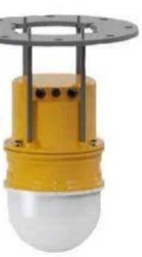
3D Robot Level Scanner for Silos and Bunkers
A scanning radar that sees the whole surface, not a single point. It sweeps 360° horizontally and 160° vertically to build a 3D point cloud and turns it into volume and mass with an error under 3%.
30 m
Range
±2.5 cm
Accuracy
Under 3%
Volume Error
IP67
Protection
DEFINITION & OVERVIEW
What is a 3D Robot Level Scanner?
Most level instruments measure one point. A conventional radar or ultrasonic transmitter points down, measures the distance to the material below, and reports that distance as the level. That works well when the surface is flat. It works poorly in a coal bunker, where material heaps into a cone, draws down into a crater, or piles against one wall.
The 3D robot level scanner measures the whole surface. It is an FMCW scanning radar that sweeps 360° horizontally and 160° vertically, collects thousands of distance readings, and builds a 3D point cloud of what is inside. From that cloud, it works out the volume and mass, with a volume error of under 3%.
John Finlay's scanner has a range of 30 m and an accuracy of ±2.5 cm in an IP67 housing that is commissioned over WiFi. Up to eight radars can work from one host, so a large silo or a row of bunkers can be covered by one system. For single-point level measurement, see our Radar Level Transmitter and Ultrasonic Level Transmitter.
Sees the Whole Surface
A 360° by 160° sweep builds a 3D picture, so uneven heaps and craters are measured, not guessed.
Volume and Mass, Not Just Level
The point cloud gives volume and mass with an error under 3%, which is what inventory and planning actually need.
One Host, Up to Eight Radars
Cover a large silo or several bunkers from a single host, commissioned over WiFi.
Parameter | Value |
|---|---|
Measuring Principle | FMCW scanning radar |
Scan Angle | 360° horizontal, 160° vertical |
Range | 30 m |
Accuracy | ±2.5 cm |
Output | 3D point cloud; volume and mass |
Volume Error | Under 3% |
Protection | IP67 |
Commissioning | WiFi |
Radars per Host | Up to 8 |
KEY FEATURES
Key Features & Performance Highlights for 3D Robot Level Scanner for Silos and Bunkers
A Measurement That Matches the Material
Coal does not lie flat. A scanner that maps the full surface reports the volume that is really in the vessel, instead of extrapolating from one spot that may be the top of a cone or the bottom of a crater.
Millimetre-Class Precision at Bunker Scale
±2.5 cm accuracy at a range of 30 m, with a volume error under 3%, gives a stock figure a planner can trust.
Radar, So Dust Is Not the Problem
Radar works through the dust that fills a silo during loading, where optical methods struggle. IP67 protection suits a harsh bunker environment.
Scales with the Site
Up to eight radars per host, with WiFi commissioning, so extra vessels can be added without rebuilding the system.
Volume and Mass Together
The point cloud is converted to volume and mass.
WORKING PRINCIPLE
How the 3D Robot Level Scanner Works
It maps the surface the way a lighthouse maps a coastline, only in three dimensions.
Radar Sweeps the Vessel
The FMCW radar scans 360° horizontally and 160° vertically from the roof of the silo or bunker.
Distances Are Measured Point by Point
Each radar return gives the distance to a point on the material surface, with ±2.5 cm accuracy.
A 3D Point Cloud Is Built
The readings combine into a 3D model of the material surface, showing heaps, slopes and craters.
Volume and Mass Are Calculated
Software works out volume and mass from the model, with a volume error under 3%.
Up to Eight Radars per Host
Several scanners can share one host to cover a large vessel or several bunkers.
TECHNICAL SPECIFICATIONS
3D Robot Level Scanner | Full Specification
Parameter | Value |
|---|---|
Principle | FMCW scanning radar |
Scan Angle | 360° horizontal, 160° vertical |
Range | 30 m |
Accuracy | ±2.5 cm |
Output | 3D point cloud; volume and mass |
Volume Error | Under 3% |
Protection | IP67 |
Commissioning | WiFi |
Radars per Host | Up to 8 |
COMPARISON
3D Scanner vs. Single-Point Radar Level
3D Robot Level Scanner
Single-Point Radar Level Transmitter
Applications of the 3D Robot Level Scanner
Wherever the shape of the material matters as much as its height.
Raw Coal Bunkers
Measures how much feed is really in the bunker, including uneven piles.
Clean Coal and Product Silos
Volume and mass of stored product for loading and dispatch planning.
Inventory and Stock Accounting
A volume and mass figure that can be compared with weighing data.
Large Vessels Needing Several Scanners
Up to eight radars per host cover big or multiple vessels.
Dusty Loading Areas
Radar keeps reading through the dust cloud created while a bunker is filled.
About John Finlay
Level Instrumentation Supplier in India
Why John Finlay?
<3%
Volume Error
From a 3D point cloud of the whole surface, not a single-point estimate.
130+
Coal Washery Projects
Completed EPC projects worldwide, including Asia’s largest coking coal washery at 30 MTPA.
EPC
Full Circuit Supply
Supplied as part of a complete instrumentation and automation offering across the coal preparation flowsheet.
IN
India-Based Support
Manufactured at Hefei John Finlay Mining Equipment Co., Ltd. and supported locally in India for installation, commissioning, spares and service.
3D Robot Level Scanner | Frequently Asked Questions
Common questions from plant engineers measuring silos and bunkers.
It measures the shape of the material surface with a scanning radar and builds a 3D point cloud. From that, it works out volume and mass, not just a single-level reading.
Distance accuracy is ±2.5 cm at a range of up to 30 m, and the volume error is under 3%.
A single-point radar reads one spot, which may not represent a heaped or cratered surface. A scanner maps the whole surface. For flat-surface liquids and tall vessels, a single-point unit is simple and economical. See our Radar Level Transmitter page.
Radar reads through dust, which is why it suits bunkers and silos that fill with a dust cloud during loading. The housing is IP67.
Up to eight radars per host, which covers a large silo or a row of bunkers.
Over WiFi.
Want to know exactly how much is in your bunkers?
Our engineers can help you plan scanner coverage for your silos and bunkers.
Talk to an ExpertRelated Equipment
Instrumentation Overview
All instruments, including the General Instrumentation section.
Radar Level Transmitter
Single-point radar level for ranges to 120 m.
Ultrasonic Level Transmitter
Non-contact level to 15 m with no commissioning steps.
3D Unmanned Medium Addition System (S7)
The 3D laser scanning system for the magnetite stockpile.